Image


Fast, affordable Internet access for all.
Old /tags-176
Last August, we wrote and podcasted about the results of a broadband feasibility study for the City of Missoula, which recommended developing an open access network with approximately 60 miles of underground fiber through a public private partnership. The study also demonstrated a significant need for improved connectivity in the central business district, with almost 40% of businesses saying their connections were insufficient for their needs. The study also recommended a variety of fairly small policy changes to encourage the spread of fiber optics, such as a “dig once” conduit policy.
Early in December, the Missoula City Council acted on at at least one of those recommendations by lowering the fee the city charges for excavating and installing new fiber optic lines in the public right-of-way by 75 percent. City Councilwoman Caitlin Copple, who has spearheaded the efforts for better connectivity in Missoula and appeared on our Broadband Bits podcast in August, described lowering the fee this way to the Missoulian newspaper:
“It’s a gesture of good will to the service providers that we want to work with them,” said Copple, who chairs the city’s Economic Development Subcommittee. “It was a unanimous vote, and it shows Missoula is serious about business.”
The city also released a map, compiled by a third party, that shows all the privately-owned fiber assets in Missoula’s central business district. It is purposely unclear which company owns which segments of fiber, as the providers would only participate if their information was anonymized to protect their competitive edge. While certainly not present on every street, the map shows that there is a significant amount of fiber already in the ground. From the Missoulian:
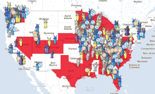
We have updated and expanded our interactive Community Owned Network Map [Non-interactive screen shot above]. The map continues to track the FTTH, cable networks, and partial fiber networks owned by local governments in the U.S. Now it also tracks dark fiber networks, publicly owned stimulus funded networks, and which networks are already advertising and/or delivering gigabit services. We are presently tracking networks in 342 communities, including:

The safety lecture continues... "In the unlikely event…" This is a very suspect phrase! Especially, coming as it does, from an industry that is willing to lie about arrival and departure times!After reading Larry Press' account of ordering DSL from Verizon, I couldn't help but wish George Carlin were still with us and also a giant broadband geek. Larry Press' account on dealing with Verizon should be read in full, but this is what got me thinking:
Last week I ordered 7 mbps service from Verizon, but, after they switched it on, I was only getting about 1.5 mbps. I assume there were tons of retransmission errors due to an overly aggressive modulation scheme. When I called to complain, a Verizon "technician" kept me on the phone … [and finally] got his bosses permission to schedule a "truck roll" to come to my house and fix the problem. The minute the driver arrived, he told me that, at 9,000 feet from my central office, there was no way I was going to get 7 mbps.We have long known that Verizon and similar companies are similarly willing to lie about their available broadband speeds (yah, I know, I'm no Carlin). As I recently testified in a MN House hearing, the Connected Nation maps systematically overstate available broadband (particularly for DSL). And of course they do - Verizon doesn't even know what it can achieve at each premises (thought it damn well should know what it cannot offer 9,000 feet from the DSLAM). The dumb question is: Does Verizon actually maintain a database of what it could really offer, in real world conditions, to each house (or what speeds are actually achieved when they take service).

On Wednesday, I testified at an informational hearing before the House Telecom Subcommittee of the Minnesota Legislature. Connected Nation was giving an update on their contract to map broadband availability in Minnesota and I wanted to record some dissent regarding their claims and the usefulness of maps in general. For those who have not used the Connected Nation tool, it is horrible. The interface is as klunky as can be, with significant lag between clicking the screen and anything actually occurring. I am happy to note that they will soon be rolling out a better tool that may be better, though it appears to still need a fair amount of work before it would really be effective. I noted that I see no reason to trust their maps.
As I have previously ranted, Connected Nation is a creature of the telecommunications industry and acts in their interests. They appear to systematically overstate availability (which may simply be a function of the unreliable information the companies provide to them). I spot checked a few addresses where I know firsthand what is available and found claims of much faster speeds. Connected Nation has always been clear that when anyone finds discrepancies, CN will correct the map. How generous. They get millions to make inaccurate maps and we get to spend hours trying to get their tool to work and then send them corrections. This is not a good process. Beyond the Connected Nation problem is the fact that legislatures across the country have refused to ask for the data that matters. Without cost information, how are we to make policy or even judge what speeds are "available." If the only option is a 1Mbps/256kbps connection for $80/month, is that really an option for people living in a rural area where incomes tend to be lower? Hardly. Without cost information, there is little these maps will tell us.

First off, compared to the VTel project, I'm immediately inclined to favor ECF's by the simple fact that they're a public project, which the original stimulus language suggested should get priority, and they're looking for a loan rather than a grant, and I think so long as a project will be self-sustaining, it's always better to loan money that you'll get back some day than to just give handouts of free money. I also prefer ECF's project because they're going to be bringing fiber to every home in their service area. They're not going to leave anyone behind, creating second-class digital citizens. Finally, I think that ECF's project has a greater chance of establishing a model that the rest of the country can learn from, proving both that fiber can be economical in rural areas and that open multi-service networks can be financially viable.Vermont was also one of the four states to receive the first awards for mapping broadband.
COOK Report: In other words, if a Telco says, “we provide access there” what do the people say about it? Do they have service? Is it available? Can they afford to buy it? Can they use it, and do they use it? Wedeman: That’s why the definition of “under-served” is so important, because a lot of people have construed this to be unique to rural areas. It is clear that in many of these rural locations there is literally nothing. However, what is not so obvious to many is that lots of people in urban areas don’t even have phones, let alone high-speed Internet connections. They may use a pay phone, or a cell phone. Before the mass adoption of cell phones, the only service they had was provided by pay phones.
According to a map made available online last week by the industry-backed nonprofit Connected Nation, broadband is available to 92 percent of North Carolina households. That number seems too high to some legislators and public interest advocates, who are concerned that overstating the amount of access will hurt the state's chances of receiving federal grants. "You'll be pleased that over 90 percent of the households in North Carolina are now served by one or more broadband providers," Connected Nation representative Joe Mefford said during the unveiling of the map at the state legislature last week. "The maps also, by that, indicate that there's been a huge investment in broadband in this state already."I have dealt with Connected Nation's maps here in Minnesota, and the technology is awful. In an age of Google Maps and impressive mashups, they produce clunky maps at sufficiently large file sizes that you need fast broadband to open them. I pity anyone trying to use their maps on a slow DSL connection. On top of that, they continue to classify cellular services (that often come with a very small monthly cap) as broadband in order to overstate how many people have access. Fortunately, Fiona spoke to Craig Settles and he offers some great commentary.
Craig Settles, an Oakland, Calif.-based consultant on broadband technology, said the broadband stimulus has been hijacked by the telecommunications industry. "It started as a noble effort," he said, "but it's a complete and total travesty all around." Each state must choose one mapping entity in order to be eligible for any of the broadband stimulus money. There is $350 million set aside specifically for mapping, to be divided between the states. That's too much money, Settles thinks, and the terms favor Connected Nation and the industry. "We're going to pay you millions of dollars to collect all this information, but you can't tell anybody what this information is? That is the most stupid-ass thing on the planet.